> ## Documentation Index
> Fetch the complete documentation index at: https://docs.cadmus-cad.app/llms.txt
> Use this file to discover all available pages before exploring further.
# Map, Location, and RapidSOS in Cadmus CAD
> Use the Cadmus map to plot units and calls, review staged RapidSOS alerts by icon type, and create CFS records from emergency data.
The Cadmus map gives you a live picture of units, open calls, and - when enabled - **staged RapidSOS alerts** with partner-specific icons and detail panels. Use it to validate addresses, share coordinates with responders, track a phone number live, or **Create New CFS** directly from an alert pin.
Published GIS data from Web Admin also feeds address validation and map overlays for the selected organization. Dispatchers do not upload GIS files themselves, but they will see the effects of published GIS data here.
## Opening the Map
Press **F4** or click **Map** in the header. On desktop, the map may open in a separate window you can keep beside the dispatch queue.
## Map Layers
Enable only the layers you need - dense maps can slow older workstations.
| Layer | What it shows |
| ------------------------ | ----------------------------------------------------- |
| **Patrol Units** | GPS positions of active patrol vehicles and apparatus |
| **Personnel** | On-duty personnel locations from handheld GPS |
| **Active Calls** | Pin for each open call for service |
| **RapidSOS Locations** | Staged RapidSOS alerts and live tracks |
| **RapidSOS Breadcrumbs** | Movement trail during an active phone track |
Weather and radar overlays are available from the map layer toolbar when your deployment includes them.
Depending on your organization's GIS configuration, additional operational overlays may appear after an OrgAdmin or CadmusAdmin publishes new GIS data.
## Unit and personnel map icons
Cadmus uses different icons so you can tell **apparatus** telemetry apart from **handheld officer** GPS:
| Icon | Meaning |
| ----------------------------------------------------- | --------------------------------------------------------------------------------------------------------- |
| **Vehicle** (patrol car, fire truck, ambulance, etc.) | Apparatus or MDT-reported unit position; icon **rotates** with travel direction when heading is available |
| **Phone** (upright) | Handheld officer GPS — person location, not the apparatus |
Personnel on the **Personnel** layer also display with a phone-style marker and name label.
If a unit shows a vehicle icon at the station but an officer’s phone icon is moving toward a call, trust the phone fix for **where that officer is** and the vehicle icon for **where the apparatus last reported**.

 ## Map Controls
* **Zoom In / Zoom Out** — adjust viewing level
* **Reset View** — return to default center and zoom
* **Always on Top** — keep map above other apps (desktop)
* **Toggle Fullscreen** — expand map to full screen
* **Select Map Style** — street, satellite, or dark basemap
## Location on Calls
Every call detail panel includes **Location details**:
* **Edit address** — update as the caller provides corrections
* **Validate and Geocode Address** — resolve to map coordinates
* **Copy GPS coordinates** — copy lat/long for radio or notes
GPS coordinates are location PII. Follow agency CJIS and privacy policy before sharing externally.
Confirm the map pin matches reported cross streets before dispatching. Geocoding may snap to the nearest routable address.
***
## RapidSOS alerts on the map
When RapidSOS is enabled, the backend **stages** alerts from configured polling (sandbox demo numbers) and/or the EDX real-time feed. Staged alerts appear as pins on the map when **RapidSOS Locations** is on.
### Pin icon types (primary category)
Each pin uses a **primary icon** based on the highest-priority partner data in the alert:
| Icon / category | Typical source | Pin color |
| ----------------------- | -------------------------------------- | ------------------------------ |
| **Vehicle crash** | SiriusXM telematics crash data | Red / crash styling |
| **Active assailant** | Weapon-detection or assailant partners | Deep orange |
| **Alarm** | Home security (e.g. Cove) | Amber / alarm styling |
| **Medical** | Emergency health profile (EHA) | Pink / medical styling |
| **Live media** | Streaming or media partners | Purple |
| **Mobile / ride-share** | Mobile app vehicle data | Teal |
| **Location only** | GPS fix without rich partner payload | **Accuracy color** (see below) |
| **Device source** | Phone/device metadata emphasis | Neutral with phone badge |
Small **badge icons** may appear on the pin when multiple data types are present (Location, Crash, Medical, Contacts, Media, Alarm, Source).
### Location-only accuracy colors
When the alert is primarily a GPS fix (no crash/alarm/medical partner block), the pin color reflects **uncertainty radius**:
| Color | Approximate accuracy |
| ------ | -------------------- |
| Green | ≤ 10 m |
| Blue | ≤ 25 m |
| Yellow | ≤ 50 m |
| Orange | ≤ 100 m |
| Red | > 100 m or unknown |
### Map view — alert plotted on the map
## Map Controls
* **Zoom In / Zoom Out** — adjust viewing level
* **Reset View** — return to default center and zoom
* **Always on Top** — keep map above other apps (desktop)
* **Toggle Fullscreen** — expand map to full screen
* **Select Map Style** — street, satellite, or dark basemap
## Location on Calls
Every call detail panel includes **Location details**:
* **Edit address** — update as the caller provides corrections
* **Validate and Geocode Address** — resolve to map coordinates
* **Copy GPS coordinates** — copy lat/long for radio or notes
GPS coordinates are location PII. Follow agency CJIS and privacy policy before sharing externally.
Confirm the map pin matches reported cross streets before dispatching. Geocoding may snap to the nearest routable address.
***
## RapidSOS alerts on the map
When RapidSOS is enabled, the backend **stages** alerts from configured polling (sandbox demo numbers) and/or the EDX real-time feed. Staged alerts appear as pins on the map when **RapidSOS Locations** is on.
### Pin icon types (primary category)
Each pin uses a **primary icon** based on the highest-priority partner data in the alert:
| Icon / category | Typical source | Pin color |
| ----------------------- | -------------------------------------- | ------------------------------ |
| **Vehicle crash** | SiriusXM telematics crash data | Red / crash styling |
| **Active assailant** | Weapon-detection or assailant partners | Deep orange |
| **Alarm** | Home security (e.g. Cove) | Amber / alarm styling |
| **Medical** | Emergency health profile (EHA) | Pink / medical styling |
| **Live media** | Streaming or media partners | Purple |
| **Mobile / ride-share** | Mobile app vehicle data | Teal |
| **Location only** | GPS fix without rich partner payload | **Accuracy color** (see below) |
| **Device source** | Phone/device metadata emphasis | Neutral with phone badge |
Small **badge icons** may appear on the pin when multiple data types are present (Location, Crash, Medical, Contacts, Media, Alarm, Source).
### Location-only accuracy colors
When the alert is primarily a GPS fix (no crash/alarm/medical partner block), the pin color reflects **uncertainty radius**:
| Color | Approximate accuracy |
| ------ | -------------------- |
| Green | ≤ 10 m |
| Blue | ≤ 25 m |
| Yellow | ≤ 50 m |
| Orange | ≤ 100 m |
| Red | > 100 m or unknown |
### Map view — alert plotted on the map
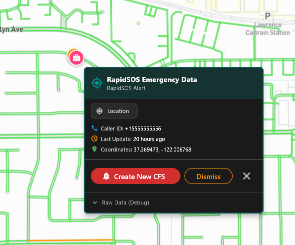 ### Click a RapidSOS pin — Emergency Data panel
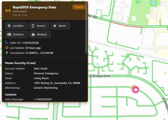
Click any RapidSOS pin to open **RapidSOS Emergency Data**. The panel shows:
* **Header** — alert label and partner source (example: *Cove Alarm*, *Source: Cove*)
* **PINNED** badge when the panel is locked open
* **Category badges** — quick filters: Location, Source, Alarm, Contacts, Medical, etc.
* **Caller ID**, **Last update** (live age), **Coordinates**
* **Partner sections** — expandable blocks (Home Security, Medical profile, Crash details, etc.)
* **Create New CFS** — opens [Import RapidSOS Alert](/dispatch/rapidsos-import-cfs)
* **Dismiss** — remove staged alert from the map (per workflow)
* **Close** (X) — close the panel
* **Raw Data (Debug)** — optional JSON for administrators/testing
### Click a RapidSOS pin — Emergency Data panel
Click any RapidSOS pin to open **RapidSOS Emergency Data**. The panel shows:
* **Header** — alert label and partner source (example: *Cove Alarm*, *Source: Cove*)
* **PINNED** badge when the panel is locked open
* **Category badges** — quick filters: Location, Source, Alarm, Contacts, Medical, etc.
* **Caller ID**, **Last update** (live age), **Coordinates**
* **Partner sections** — expandable blocks (Home Security, Medical profile, Crash details, etc.)
* **Create New CFS** — opens [Import RapidSOS Alert](/dispatch/rapidsos-import-cfs)
* **Dismiss** — remove staged alert from the map (per workflow)
* **Close** (X) — close the panel
* **Raw Data (Debug)** — optional JSON for administrators/testing
 Turn on **RapidSOS Locations** in **Map Layers** if pins are not visible.
Review caller ID, coordinates, and partner sections in the Emergency Data panel.
Click **Create New CFS** to open the import form with fields pre-filled. See [Import RapidSOS CFS](/dispatch/rapidsos-import-cfs).
Use **Dismiss** for invalid or duplicate sandbox alerts, or **Close** if no action is needed.
***
## Track Phone Number (live LEI / RAD-E)
Separate from staged alerts, dispatchers can **track a phone number** live:
From the map toolbar, choose **Track Phone Number** (or **RapidSOS Tracking**).
Example sandbox demo: `+15555555556`
Cadmus queries RapidSOS RAD-E (crash location) and LEI (device location). A pin appears when data returns.
Click **Stop Tracking** to end polling and protect caller privacy.
If tracking cannot start (LEI disabled, no location returned, or credentials missing), Cadmus shows a message on the map — the screen will **not** go blank. Contact your admin to enable **LEI** and **RAD-E** under Runtime Settings.
RapidSOS depends on carrier/device data. Always corroborate location with the reporting party. Do not treat map data as the sole source of truth.
## RapidSOS Lookup
When enabled, **RapidSOS Lookup** in the header lets you query by phone number and **Show on Map** for a one-time plot (distinct from staged alerts and live track).
## Configuration
Agency administrators configure RapidSOS in **Web Admin → Integrations → RapidSOS Management**:
* **Credentials** — OAuth client for Sandbox or Production
* **Runtime Settings** — per-org toggles for RAD-E, LEI, EDX, polling numbers, dispatch agency
See [RapidSOS Management](/admin/rapidsos-management).
## GIS-driven address behavior
When dispatchers enter or revalidate an address, Cadmus can use organization-scoped GIS data to:
* confirm the address exists
* place the incident pin more accurately
* support common-place and operational matching
* determine whether the address is outside configured operational coverage
If known good addresses stop validating after an admin publishes new GIS data, escalate to your OrgAdmin or Cadmus support and provide the affected address examples and timestamps.
Turn on **RapidSOS Locations** in **Map Layers** if pins are not visible.
Review caller ID, coordinates, and partner sections in the Emergency Data panel.
Click **Create New CFS** to open the import form with fields pre-filled. See [Import RapidSOS CFS](/dispatch/rapidsos-import-cfs).
Use **Dismiss** for invalid or duplicate sandbox alerts, or **Close** if no action is needed.
***
## Track Phone Number (live LEI / RAD-E)
Separate from staged alerts, dispatchers can **track a phone number** live:
From the map toolbar, choose **Track Phone Number** (or **RapidSOS Tracking**).
Example sandbox demo: `+15555555556`
Cadmus queries RapidSOS RAD-E (crash location) and LEI (device location). A pin appears when data returns.
Click **Stop Tracking** to end polling and protect caller privacy.
If tracking cannot start (LEI disabled, no location returned, or credentials missing), Cadmus shows a message on the map — the screen will **not** go blank. Contact your admin to enable **LEI** and **RAD-E** under Runtime Settings.
RapidSOS depends on carrier/device data. Always corroborate location with the reporting party. Do not treat map data as the sole source of truth.
## RapidSOS Lookup
When enabled, **RapidSOS Lookup** in the header lets you query by phone number and **Show on Map** for a one-time plot (distinct from staged alerts and live track).
## Configuration
Agency administrators configure RapidSOS in **Web Admin → Integrations → RapidSOS Management**:
* **Credentials** — OAuth client for Sandbox or Production
* **Runtime Settings** — per-org toggles for RAD-E, LEI, EDX, polling numbers, dispatch agency
See [RapidSOS Management](/admin/rapidsos-management).
## GIS-driven address behavior
When dispatchers enter or revalidate an address, Cadmus can use organization-scoped GIS data to:
* confirm the address exists
* place the incident pin more accurately
* support common-place and operational matching
* determine whether the address is outside configured operational coverage
If known good addresses stop validating after an admin publishes new GIS data, escalate to your OrgAdmin or Cadmus support and provide the affected address examples and timestamps.